Water supply systems are a vital component of any modern city, and Vancouver is no exception, writes vancouver-future. The city’s water system has a fascinating history with numerous interesting facts.
Vancouver’s watersheds provide drinking water to approximately 2.5 million people, including those in Langley and Richmond. Each watershed has its own reservoir, monitored and managed by Metro Vancouver.
In this article, based on information from metrovancouver.org, we delve into the development of Vancouver’s water supply system.
Beginnings
The population of Vancouver began to grow rapidly in the late 1880s.
In April 1886, two companies, Vancouver Water Works Company and Coquitlam Water Works Company, were established to ensure a reliable and efficient water supply.
By 1887, the Capilano River was selected as Vancouver’s primary water source, with a watershed constructed 11 kilometres upstream from the river’s mouth.
As Vancouver’s population increased, it became clear that the city would need an additional water source.
A New Development
In 1905, Vancouver’s mayor, Frederick Buscombe, identified the Seymour River as a valuable water resource.
By 1908, the first intake was constructed on the Seymour River, consisting of a wooden pipe situated 11 kilometres upstream at an elevation of 140 metres. A second intake followed in 1913.
In 1927, the wooden pipe was replaced with a steel one.
In 1928, a small dam known as Seymour Falls Dam was built just north of the Seymour intake, creating a 180-acre reservoir.
The dam and reservoir were expanded to their current size in 1961.
A New Company
Since 1892, Coquitlam Lake had been supplying water to New Westminster. On October 18, 1902, responsibility for this supply was transferred to Vancouver Power Company.
Initially, the water intake was located at the lower end of the lake. However, in 1905, a new intake structure was built.
In August 1909, Vancouver Power Company secured government rights to the water within the lake’s boundaries.
Logging Activities
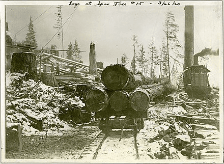
In 1918, Capilano Timber Company began leasing timber rights within the Capilano watershed area, initiating clearcutting activities.
The logging plans became widely known to the local population by 1916, and by 1918, clearcutting was in full swing near the Capilano watershed.
Investigations by Vancouver specialists revealed that logging was conducted at excessive elevations, on steep slopes, and near river mouths.
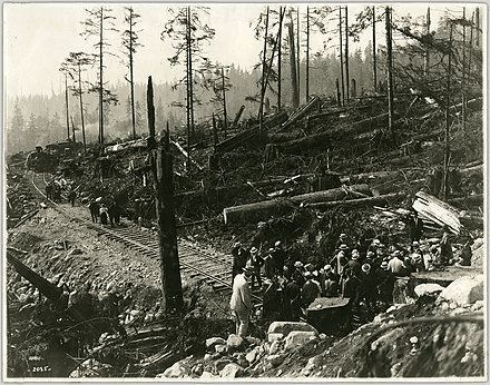
These activities raised significant concerns among Vancouver residents and politicians about the potential impact on water quality.
Widespread logging also led to frequent wildfires, with one fire destroying over 3,000 acres within the watershed.
A Significant Event
On February 3, 1926, the Vancouver Water District was officially formed.
In 1927, the government granted the district leases for timber and land within the Seymour and Capilano watersheds.
By 1931, Capilano Timber Company ceased its logging operations in the Capilano watershed area.
The Vancouver Water District subsequently purchased all logging companies operating in the Capilano watershed, ensuring the complete protection of the Seymour and Capilano watersheds.
Continued Challenges
Throughout the 1930s to 1950s, the Vancouver Water District maintained that logging should be restricted to areas outside watershed boundaries.
By 1952, logging companies began advocating for expanded operations near the watersheds, claiming it would generate significant profits and protect watersheds from potential wildfires.
In December 1958, logging operations began near the Seymour watershed to clear land for a new reservoir.
This project included clearing 487 acres and constructing a five-mile access road near Seymour Reservoir, generating $540,000 in revenue from the timber.
In 1961, 316 additional acres were logged in the Seymour watershed to prevent aphid infestations.
End of Logging
By 1960, the Coquitlam and Seymour watersheds were largely roadless, though they contained some transmission lines.
From 1961 to 1992, logging roads were constructed through the watersheds, leading to extensive deforestation in old-growth forests and on steep mountain slopes.
Despite hydrological studies showing otherwise, the Vancouver Water District argued that logging improved water quality.
Logging operations continued until 1999, when the district decided to cease all logging activities within Vancouver’s watersheds.
About the Watersheds
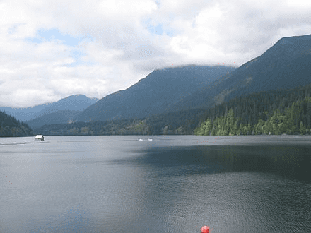
The Capilano Watershed spans approximately 19,500 hectares. All streams in the area flow into the Capilano River, eventually reaching Capilano Lake, where a reservoir, built in 1954, stretches six kilometres in length, 800 metres in width, and 75 metres in depth.
The Seymour Watershed is the narrowest, covering just over 12,000 hectares and holding 32 billion litres of water. It fills primarily in the autumn, winter, and spring.
Initially, Seymour Lake served as a small reservoir created in 1928 with the construction of Seymour Falls Dam. The dam was expanded in 1960, increasing the reservoir’s length to 6.5 kilometres.
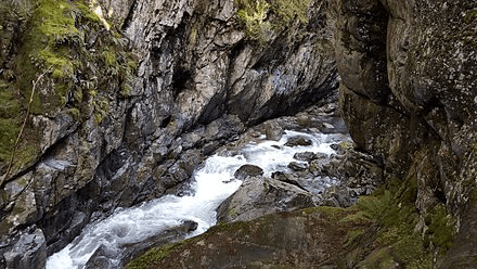
All of Vancouver’s watersheds are closed to the public to prevent contamination.
Occasionally, guided tours are offered, following strict procedures and during specific times of the year. Interested visitors must register on a designated website, as participation without prior registration is not permitted.
Significant Event
On February 3, 1926, the Vancouver Water District was officially established.
In 1927, the government granted the district leases for timber and land within the Seymour and Capilano watersheds.
By 1931, Capilano Timber Company ceased its logging operations in the Capilano watershed.
The Vancouver Water District purchased all the logging companies operating in the Capilano watershed, leading to the designation of Seymour and Capilano as completely closed watersheds.
Changing Circumstances
Between the 1930s and 1950s, the Vancouver Water District maintained that logging should only occur outside watershed boundaries.
In 1952, many logging companies began advocating for the continuation of logging near watersheds, arguing that it could generate significant profits and protect watersheds from wildfires.
However, by the late 1950s, attitudes towards logging began to shift.
On December 16, 1958, logging began near the Seymour watershed to clear land for a new reservoir.
The Vancouver Water District hired experts to oversee the operation, resulting in the clearing of 487 acres and the construction of a five-mile access road near Seymour Reservoir.
The harvested timber generated $540,000 in revenue.
In 1961, 316 acres of land within the Seymour watershed were cleared to prevent aphid infestations.
End of Logging
Until 1960, the Coquitlam and Seymour watersheds lacked roads, although some power lines were present.
Between 1961 and 1992, logging roads were constructed in the three watersheds, cutting through old-growth forests and steep mountain slopes.
The Vancouver Water District continued to assert that logging improved water quality, despite hydrological studies suggesting otherwise.
Logging persisted until 1999, when the district decided to cease all logging operations within Vancouver’s watersheds.
About the Watersheds
The Capilano Watershed spans approximately 19,500 hectares. All streams in this area flow into the Capilano River and eventually into Capilano Lake, where a reservoir built in 1954 now stretches six kilometres in length, 800 metres in width, and 75 metres in depth.
The Seymour Watershed, the narrowest, covers just over 12,000 hectares and can hold 32 billion litres of water. It typically fills during the autumn, winter, and spring seasons.
Initially, Seymour Lake served as a small reservoir created in 1928 with the construction of Seymour Falls Dam.
The dam was expanded in 1960, increasing the reservoir’s length to 6.5 kilometres.
Each of Vancouver’s watersheds is closed to the public to prevent contamination risks.
However, guided tours are occasionally permitted, following strict procedures and during specific times of the year. Those interested in visiting the watersheds must closely monitor the tour schedule and register on a designated website, as registration is mandatory to gain access.